
About Fontvieille
Fontvieille – Funtanaveya in Monégasque – did not exist before 1966. Between 1966 and 1973 the principality won a whole quarter from the sea west of the Rock, to a plan by the architect Manfredi Nicoletti, the project of Prince Rainier III. The result is Monaco's most planned district: a marina, a park, offices, light industry and housing, including the state housing meant to keep rents within reach of Monégasques.
Port de Fontvieille, edged by the Quai Jean-Charles-Rey, is one of the principality's marinas, its quay lined with restaurants. Behind it rise the Stade Louis II – the football ground of AS Monaco with a swimming pool, a diving pool and a sports hall under the same roof – and the principality's heliport. The Église Saint-Nicolas, a shopping centre with its arcade and a fire-and-rescue centre complete the neighbourhood.
Fontvieille is also the museum quarter by the water: around the Chapiteau de Fontvieille stand the stamps and coins museum, the Prince's car collection and the naval museum, and the Princess Grace rose garden lies in the park. A small strip of the reclaimed land lies in the French commune of Cap-d'Ail.
The lists for Fontvieille
- Arts centre · FontvieilleEspace Léo Ferré
Arts centre on Avenue Albert II
- Gallery · FontvieilleMonalisa motorsport gallery formula 1
Gallery on Quai Jean-Charles Rey
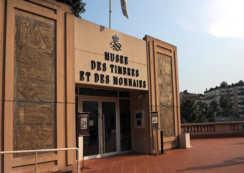
- Museum · FontvieilleMusée des Timbres et des Monnaies
The Prince's collections of stamps and coins, on the Terrasses de Fontvieille
- Museum · FontvieilleMusée naval
Ship models and naval history on the Terrasses de Fontvieille
- Public building · FontvieilleMuseum of Stamps and Coins
![musée des timbres et des monnaies de Monaco, Fontvieille]()
The Prince's collections of stamps and coins, on the Terrasses de Fontvieille
- Café · FontvieilleCafé du Cirque de Monte-Carlo
The café of the Chapiteau de Fontvieille
- Attraction · FontvieilleChapiteau de Fontvieille
The permanent big top on Avenue des Ligures, Fontvieille
- Café · FontvieilleEmilie’s Cookies
A cookie café on Promenade Honoré-II
- Museum · FontvieilleMusée naval
Ship models and naval history on the Terrasses de Fontvieille
- Park · FontvieilleParc paysager de Fontvieille
Fontvieille's landscape park with its sculpture trail by Arman and César
- Garden · FontvieilleRoseraie Princesse Grace
Rainier III's rose garden of 1984 in memory of Princess Grace, with 4,000 roses
Search Monaco
What to see in Fontvieille
 Museum of Stamps and CoinsThe Museum of Stamps and Coins is located in the Fontvieille section of Monaco. It tells the postal history of the principality, and contains a displ…Валерий Дед · CC BY 3.0
 Monaco HeliportMonaco Heliport (French: Héliport de Monaco, ICAO: LNMC), also known as Monte Carlo Heliport, is a heliport situated in the district of Fontvieille in…giggel · CC BY 3.0
 Stade Louis IIThe Stade Louis II (French pronunciation: [stad lwi dø], lit. 'Louis II Stadium'), or simply Louis II, is a stadium located in the Fontvieille distric…Валерий Дед · CC BY 3.0
 Saint Nicholas ChurchInfattiVedeteCheViDice · CC BY-SA 3.0
 Port of FontvieilleMister No · CC BY 3.0
 Salle Gaston MédecinSalle Gaston Médecin, or Salle Omnisports, is a multi-purpose indoor sports arena, that is located in the Fontvieille district, within the Principalit…Gael13011 · CC BY-SA 4.0Fontvieille Park and Princess Grace Rose GardenThe Fontvieille Park and the Princess Grace Rose Garden are two municipal parks in the Fontvieille district of Monaco. The parks are a combined 4 hect…Monalisa motorsport gallery formula 1
 Princess Grace Rose GardenMister No · CC BY 3.0
Places
Eat & drink
- A RocaFast food · Avenue Albert II
- Al denteFast food · Rue de la Lüjerneta
- Amici MieiRestaurant · Quai Jean-Charles Rey
- Amici MieiRestaurant · Quai Jean-Charles Rey
- BeefbarRestaurant · Quai Jean-Charles Rey
- Café du Cirque de Monte-CarloCafé · Avenue des Ligures
- DubernetFast food · Avenue Albert II
- Emilie's CookiesCafé · Promenade Honoré II
- Gerhard's CaféCafé · Quai Jean-Charles Rey
- Giudi'sCafé · Avenue Albert II
- GraziellaRestaurant · Quai Jean-Charles Rey
- L'En-KFast food · Avenue des Papalins
- La SalièreRestaurant · Quai Jean-Charles Rey
- Le 29Fast food · Avenue Albert II
- Le barbagiuanBar · Avenue des Papalins
- Le kiosqueCafé · Avenue Albert II
- Le MichelangeloRestaurant · Quai Jean-Charles Rey
- Le Rouge et le BlancRestaurant · Quai Jean-Charles Rey
- Les Perles de Monte-CarloRestaurant · Quai Jean-Charles Rey
- L’Épi d'ArgentCafé · Avenue des Papalins
- McDonald'sFast food · Avenue Albert II
- Moshi MoshiRestaurant · Quai Jean-Charles Rey
- Pizz'AriaRestaurant · Quai Jean-Charles Rey
- Ship and CastlePub · Quai Jean-Charles Rey
- StarbucksCafé · Promenade Honoré II
- TavoloRestaurant · Avenue des Papalins
- The Bar @ ColumbusBar · Avenue des Papalins
- Tre ScaliniRestaurant · Quai Jean-Charles Rey
Shops
- AS Monaco Football StoreSports · Promenade Honoré II
- BentleyCar · Rue du Gabian
- BMWCar · Rue du Gabian
- Boutique de La Collection de voitures anciennes de SAS le Prince de MonacoGift · Avenue Albert II
- Brico Pro – Master ProDoityourself · Avenue Albert II
- CalipageStationery · Rue du Gabian
- CarrefourSupermarket · Avenue Albert II
- DecathlonSports · Rue de la Lüjerneta
- Heliair voyageTravel agency · Avenue des Ligures
- jet travelTravel agency · Avenue de Fontvieille
- Jouéclub!Toys · Rue de la Lüjerneta
- LamborghiniCar · Avenue de Fontvieille
- Le mediaKiosk · Avenue Albert II
- Maison MullotBakery · Avenue Albert II
- MC AutoCar · Promenade Honoré II
- Monaco bikeBicycle · Promenade Honoré II
- Monaco TelecomMobile phone · Rue du Gabian
- Papalins PressingDry cleaning · Rond-Point Papalins
- PorscheCar · Promenade Honoré II
- Quai 28 Coiffure Mixte (le)Hairdresser · Quai Jean-Charles Rey
- SeagnatureTravel agency · Avenue de Fontvieille
Culture
- Cadran solaire de FontvieilleArtwork · Promenade Honoré II
- CavalierArtwork · Avenue des Ligures
- Cavalleria EroicaArtwork · Place du Campanin
- Chapiteau de FontvieilleAttraction · Avenue des Ligures
- Couple sculptureArtwork · Avenue des Guelfes
- Espace Léo FerréArts centre · Avenue Albert II
- Et le septième jourArtwork · Avenue Albert II
- Frère et SœurArtwork · Avenue des Guelfes
- Grande baigneuse accroupieArtwork · Avenue Albert II
- Grande carpeArtwork · Avenue des Papalins
- Hommage au Professeur Gianfranco GilardiniArtwork · Avenue Albert II
- L'hommage aux éléphants de cirqueArtwork · Avenue des Ligures
- La Grande LaveuseArtwork · Avenue des Papalins
- Le PoissonArtwork · Avenue des Ligures
- Marta accovacciataArtwork · Avenue Albert II
- Monalisa motorsport gallery formula 1Gallery · Quai Jean-Charles Rey
- MotophantArtwork · Avenue des Papalins
- Moulin à huile de MonacoArtwork · Place du Campanin
- Musée des Timbres et des MonnaiesMuseum · Avenue Albert II
- Musée navalMuseum · Avenue Albert II
- NOEUD 1987Artwork · Galerie Princesse Stéphanie
- Princesse GraceArtwork · Tunnel Pont Cadre
- Promethee sculptureArtwork · Rue du Campanin
- Servi mutiArtwork · Tunnel Pont Cadre
- Sfera con sferaArtwork · Avenue des Papalins
- SolitaryArtwork · Quai Jean-Charles Rey
- stade Louis-IIArena · Avenue des Castelans
- Statue Saint-NicolasArtwork · Place du Campanin
- TorsoArtwork · Place du Campanin
- Torso desperacionArtwork · Tunnel Pont Cadre
- Woman smoking a cigaretteArtwork · Tunnel Pont Cadre
- Âne en bronzeArtwork · Avenue des Guelfes
- ÉvolutionArtwork · Avenue des Papalins
Fontvieille on the map
Events in Fontvieille
- 1974International Circus Festival of Monte-CarloEvery year in January, under the big top in Fontvieille – since 1974
- ·Herculis athletics meetingEvery summer, at the Stade Louis II
Recurring events, from Wikipedia and Wikidata. This year's dates are on the organisers' own sites.
Every street in Fontvieille – 23 street guides
- Avenue Albert II
- Avenue de Fontvieille
- Avenue des Castelans
- Avenue des Guelfes
- Avenue des Ligures
- Avenue des Papalins
- Entrée Parking
- Galerie Princesse Stéphanie
- Jetée de Cap d'Ail
- Passerelle Fontvieille
- Passerelle Wurtemberg
- Place Wurtemberg
- Place du Campanin
- Promenade Honoré II
- Quai Jean-Charles Rey
- Rond-Point Papalins
- Rue de l'Industrie
- Rue de la Lüjerneta
- Rue du Campanin
- Rue du Gabian
- Ruelle Herculis
- Tunnel Pont Cadre
- Tunnel du Millenium
Getting around
Bus lines in Fontvieille: 2, 3, 4, 5, 6, 22, N1, X3 (Compagnie des Autobus de Monaco).
Share
Its own link and its own card – for a message, a story or a plan for the evening.
Sources
Quartier boundary, buildings, streets and places: © OpenStreetMap contributors, ODbL 1.0. Sights: Wikidata (CC0), Wikipedia (CC BY-SA 4.0), Wikimedia Commons. Buses: CAM GTFS (Licence Ouverte 2.0). Sun: VERA PI's model, Copernicus GLO-30 terrain. The text: VERA PI.
Wikipédia (fr) : Fontvieille (Monaco)
Wikipédia (fr) : Urbanisme à Monaco
OpenStreetMap – Fontvieille's museums, Chapiteau and gardens
Photo: Nancy Pauwels/Adobe Stock